31: Skagway, old port town of the Klondike Gold Rush. We met some super fun local girls who were incredibly cool and showed us around.

32: We returned the favour and I gave one of them a few rides! Thanks Sarah!
 33: On our way out the Yukon treated us to these kind of views. Rainbows for days.

 34: And we made friends with other locals, too!

35: We camped for a night with our new Alaskan friends and then rode up further north. We had an Arctic Circle to reach!


36: A quick photo for home in the Yukon. Getting better at packing the bikes!
37: At the end of the day we’d cross incredibly janky ‘roads’ to find camping spots and were at times cut off by fallen trees and / or moose.


38: Time to cross the Yukon river. This far north, this ferry runs 24/7 and is the only way to get into Alaska.

39: After the ferry you go over a long, beautiful dirt ‘highway’ known as the Top of the World Highway.

40: And then you make it to Alaska! Border people were very friendly. Woo!
41: The roads did instantly turn shittier. Just rocks and mud here.


42: The scenery turning bleaker and bleaker.

43: Yet, there is an inescapable beauty and vastness about the lower Alaskan landscape. It makes you feel small.

44: Roadside maintenance, our way.

45: We came by Denali National Park and went hiking. This was the view around 1 AM. Yes, 1 AM.

46: I may or may not have snuck around a few railroads for photos. I love old rail bridges.

47: Making good time for the Arctic, it was time for new tires. Fairbanks (where this was taken) was our last stop with any kind of population over 50 people.

48: You may know this road from Ice Road Truckers. It’s known to take many lives each year, due to the bad road conditions and how remote you are. There’s only 1 stop for gas in 500+ miles.

49: We made it to the sign delineating the Arctic Circle! But, we weren’t there yet – we wanted to ride north until the road ran out.

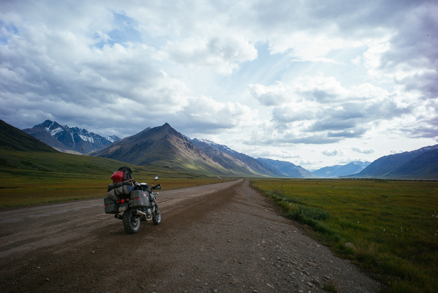
50: The foothills of the Brooks Range showed us the last mountain ridge we’d see until the Arctic Ocean (and if you’d kept going, the North Pole). The Brooks Range separates the forested landmass from the inhospitable Arctic North Slope.

51: Sure enough: we mounted the mountain pass and trees just vanished.

52: Actually, all vegetation vanished except for some bog grass. Meanwhile, we shared the road with nothing but massive speeding trucks leaving us in clouds of dust and rocks.

53: The Dalton takes its toll often. You see lots of wrecks and memorial signs for lost souls next to the road.

54: We made it!!! We were too freezing and cold to be excited. In the distance is the final human outpost before the Arctic Ocean: the Prudhoe Bay oil field and Deadhorse outpost.

55: Deadhorse has a bizarre quality to it.

56: It’s the biggest oil field in the US. We were amazed and felt strange being here, as it is all oil machinery and workers and the sun never sets.

57: We were happy to ride back south the next day.

58: A rainstorm on our heels, the terrain was turning apocalyptic.

59: The road was, predictably, just barely a road.

60: But as we came close to the pass, we remembered why we went on this ride.
61: The most beautiful place on Earth I have ever been.

62: Breath-taking light.

63: We were happy to see trees again after 300 miles!
64: Trees! And those views!


65: The storm did catch up with us eventually, but after having managed this feat we started on our way back home.

66: All in all, we rode for 11,000 miles or so from home to the end fo the road – the furthest north we could go and back. It was unforgettable. It was really nice to see the Golden Gate bridge again when I rode back into San Francisco.

Source: http://imgur.com/a/J7kZJ
More photos www.ridenorth.net and www.dewith.com